|
|
|
NORTHERN AREAS |
|
KARAKORUM
HIGHWAY |
|
Thakot |
|
Besham |
|
Chilas |
|
Jaglot |
|
GILGIT TOWN |
|
Kargah (Buddha) |
|
Gilgit Bazaar |
|
Chinar Bagh (Garden) |
|
GILGIT VALLEYS |
|
Ghizer
Valley |
|
Ishkoman
Valley |
|
Naltar
Valley |
|
Punial
(SherQila) |
|
Gupis & Yasin |
|
Phander Lake |
|
Shandur
Pass |
|
Wild Life
& Parks of Gilgit |
|
Trophy
Hunting in Gilgit |
|
HUNZA |
|
Altit
Fort & Village |
|
Baltit
Fort & Village |
|
Ganesh |
|
Karimabad |
|
Duikar
Hill |
|
Eagle's
Nest |
|
Ultar Base
Camp |
|
Day Hikes
in Hunza |
|
Wild Life
& Parks of Hunza |
|
Trophy
Hunting in Hunza |
|
Nagar
Valley & Hispar |
|
Glaciers
of Nagar Valley |
|
Day Hikes
in Nagar |
|
GULMIT & GOJAL |
|
Gulmit
Village |
|
Carpet
Weaving Center |
|
Day Hikes
From Gulmit |
|
Borit Lake |
|
Passu
Village |
|
Shimshal
Valley |
|
Sust (Pak
China Border) |
|
Khunjerab
Pass / Park |
|
Wild Life
& Parks of Gojal |
|
Trophy
Hunting in Gojal |
|
BALTISTAN (SKARDU) |
|
Rondu
Gorge |
|
Kachura
Lake |
|
Kachura
Resort |
|
Skardu
Town |
|
Khorpocho
(Mindoq) Fort |
|
Sadpara
Lake |
|
Deosai
Plateau |
|
Shigar
Valley |
|
Shigar
Fort |
|
Khaplu
Valley |
|
Hushay
Valley |
|
Day Hikes
In Baltistan |
|
Popular
Treks in Baltistan |
|
Wild Life
& Parks of Baltistan |
|
Trophy
Hunting in Baltistan |
|
NWFP |
|
Northwest Frontier Province |
|
KAGHAN VALLEY |
|
Abbotabad |
|
Balakot |
|
Shogran
|
|
Siri &
Paya Meadows |
|
Naran
(Town) |
|
Lake
Saif-ul-Maluk |
|
Lalazar
Meadows |
|
Babusar
Pass |
|
Day Hikes in
Kaghan |
|
Popular
Treks in Kaghan |
|
Trout Fishing in
Kaghan |
|
SWAT VALLEY |
|
Mingora
|
|
Saidu
Shareef |
|
Butkara |
|
Swat
Museum |
|
Marghazar
Valley |
|
Jahanabad |
|
Madyan
|
|
Bahrain |
|
Kalam |
|
Gabral
Valley |
|
Ushu
Valley |
|
Mahodand
Lake |
|
Day Hikes
in Swat |
|
Popular
Treks in Swat |
|
Trout
Fishing in Swat |
|
PESHAWAR & OUTSKIRTS |
|
Qissa
Khani Bazaar |
|
Peshawar
Museum |
|
Peshawar
University |
|
Khybar
Pass |
|
Torkham
Afghan Border |
|
Landi
Kotal |
|
Darra Adam
Khail |
|
Khybar
Steam Safari |
|
CHITRAL VALLEY |
|
Dir Town &
Panakot |
|
Lowari
Parr |
|
Kafir
Kalash |
|
Bomboret
Valley |
|
Rambur
Valley |
|
Berir
Valley |
|
Day Hikes
in Chitral |
|
Popular
Treks in Chitral |
|
Wild Life
& Parks of Chitral |
|
Trophy
Hunting in Chitral |
|
Garram
Chashma |
|
Shandur
Polo Match |
|
Ghizer
Valley |
|
MURREE & GALIAAT |
|
Murree
Hills |
|
Nathiagali |
|
Bhurban
Resort |
|
Patriata
Resort |
|
Day Hikes
in Galliat |
|
KASHMIR |
|
Muzzaffarabad |
|
Rawalakot |
|
Neelam
Valley |
|
Banjosa
Valley |
|
Kuttan &
Pir Chinasi |
|
PUNJAB |
|
Walled
City of Lahore |
|
Lahore Museum |
|
Shalimar Gardens |
|
Lahore Fort &
Hazuri Bagh |
|
The Dancing
Girls of Lahore |
|
Multan |
|
Bahawalpur |
|
Uch Sharif |
|
Lal
Suhanra National Park |
|
Cholistan
Desert |
|
Wild Life
& Parks of Punjab |
|
Trophy
Hunting in Punjab |
|
SINDH |
|
Karachi &
Outskirts |
|
Karachi
Museum |
|
Clifton &
Beaches |
|
Manora
Beach |
|
Chaukhandi
Tombs |
|
Makli Hill
Necropolis |
|
Thatta &
Keenjhar Lake |
|
Moenjodaro
Ruins |
|
Moenjodaro
Museum |
|
Hyderabad |
|
Sukkhar |
|
Bhit Shah |
|
BALUCHISTAN |
|
Quetta &
Outskirts |
|
|
|
|
|
|
|
|
|
|
|
|
|
|
|
|
|
|
|
|
|
|
|
|
|
|
|
|
|
|
|
|
|
|
|
|
|
|
|
|
|
|
|
|
|
|
|
|
|
|
|
|
|
|
|
Suggested Reading |
|
|
|
|
|
|
|
|
KARAKORUM HIGHWAY : Also known as the
"eight wonder" of the world, this grand highway connects
Pakistan to China, twisting through the three mighty ranges
of the world, the Karakorams, the Himalayas & the Pamirs - & follows
the ancient Silk Route along the Indus, Gilgit & Hunza Rivers up the
Chinese border at the Khunjerab Pass where it concludes in the
Taklamakan Desert after winding through the Pamirs & Kashgar
districts. |
|
|
For
much of the 1284 kms, the KKH crosses a high
altitude desert with less than 04 inch rainfall per year. Passing
through stupendous gorges, the road cuts along shelves on the cliff
faces as much as 500 M above the river. The highway is an
incredible feast of modern engineering & an enduring monument to the
810 Pakistanis & 82 Chinese who died forcing a road
through what has a reasonable claim to be the world's most difficult &
unstable terrain. |
|
|
The Karakorums & Himalayas began to form some 55
million years ago when the indian subcontinent drifted northwards
& collided with the Asian land mass. India is still trundling
northwards at the geologically reckless rate of 05 cm a year,
pushing the mountains up by 07 mm (1/4 of an inch) per year.
The KKH runs through the middle of this collision belt where there is
an average of one Earth Quake every 03 minutes. The Indus River
separates the Himalayas from the Karakorams and the KKH hugs the banks
of the Indus for 310 Kms on its journey North. It winds round
foot of Nanga Parbat 8125 M, the 09th highest in the world &
the last in the Himalayan Range & Rakaposhi 7788 M near Nilt in Hunza. |
|
|
It
leaves the Indus & cuts through the Karakoram Range, with 12 out of
the world's 30 highest mountains. At 4733 meters, the Khunjerab
Pass is the highest paved border crossing on a surfaced road in
the world. The highway was a joint Pakistan-China project. Completed
in 1978, it took 20 years to build and employed 15000
Pakistanis & 30,000 Chinese. The Pakistanis concentrated on the road &
the Chinese on the bridges. |
|
The
glaciers, brittle rock structures, strong winds, extremes of
temperatures from 48°C/118°F
in summers to -30°C/-22°F
in winters and the seismic activity all combined to make the
construction and today the maintenance of the highway a continual
battle. The Pakistani army, today, has deployed 1000 soldiers
to keep the road open.
|
|
THAKOT BRIDGE : The
first evidence of Chinese influence on the KKH is Thakot Bridge, 123
kilometers and about two and a half hours from Abbotabad. Like other
bridges on the KKH, it is a graceful arch of white cement, its
balustrade decorated with carved lions and lanterns and its side walls
with pastel butterflies and flowers. For the next 310 kilometers the
highway follows the Indus. The Alai Valley, east of Thakot, is reached
on a spectacular road that rises over 1000 feet to give bird’s eye
views back down to the Indus.
|
|
|
BESHAM
is a major village cut into the hillside above
the Indus along the Karakoram Highway. Half way between
Islamabad and Gilgit, Besham has become a hub of travellers due to its
strategic cross-roads joining the Swat, Gilgit and Hazara divisions.
Though it is mainly populated with the upright Kohistanis, one
finds a blend of faces from various parts of the Northern Country.
|
|
|
CHILAS is a
major town on the upper course of the Indus & a gateway
to Gilgit, Hunza, Skardu, Nanga Parbat & Kaghan Valleys. It's ancient
name was "Silvata", a Sunsikrit word which meant Rock or Stone.
The name went in vogue because of the 06th & 08th centuries
carvings & paintings on the nearby boulders at the banks of the Indus. |
|
|
|
Go on Top |
|
GILGIT
is the Capital of Northern Pakistan and a thriving frontier
town that has expanded rapidly to include over 40,000
inhabitants since the Karakoram Highway was opened in 1978. It sits in
a wide irrigated bowl 1500 meters above sea level at the
Eastern end of the Gilgit Valley. The quaint little town of Gilgit has
a cluster of interesting places in it short radius, including a
beautiful rock carving of Buddha, a victory monument of Taj Mughal,
built 700 years ago and the longest suspension bridge in
Asia ( 600 ft long ) The favorite sport in Gilgit is Polo,
which the locals claim originated here. It is a more rugged style than
the sedate variety known in the plains. The polo tournament held in
the 1st two weeks of November is a festive occasion and attracts a
large number of spectators.
|
|
|
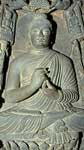
KARGAH : is famous for its
huge rock carving of Lord Buddha. This sculpture was carved in
seventh century. A monastery, 03 stupas and Gilgit manuscripts
were also found in the vicinity between 1931-39. They are now housed
in London, Delhi, Rome and Karachi. The interesting legend behind this
sculpture narrates - the villagers asked a passing saint to help them
get rid of a man- eater ogress called Yakhshini who lived at
Kargah. The saint succeeded in pinning her to the rock and declared
she won,t bother them for as long as he was alive, however, if they
buried him at the foot of the rock, she would never be free. So the
villagers killed the saint and buried him below the rock. The
Yakhshini is still slave and villagers are now safe.
|
|
|
|
Go on Top |
|
GILGIT BAZAAR is famous for its
handicrafts such as woolen gowns known as chughas, waist coats, shoes,
musical instruments, silver jewelry, caps, woolen rugs and
embroideries. The Gilgit town has also become a major dry port for
trade between Pakistan and China through Khunjerab Pass.
Due to this dramatic reform one can easily purchase China wares,
paintings, silk clothes, glass and various other Chinese products of
excellent quality. Gilgit town also house the Asia's longest
suspension bridge (600 ft long 6 ft wide).
|
|
CHINAR BAGH (garden)
: where trees as much as 300 years old haughtily overlook the Gilgit
river. This beautiful park is adorned with a bronze ibex
mounted on a tall marble pillar. The monument was built to pay tribute
to the local soldiers who sacrificed their lives for the liberation of
their motherland.
|
|
|
GHIZER VALLEY :
The 210 kms long road to Shandur Pass via Ghizer
Valley is slightly more than a dirt track cut into cliff face on the
south bank of the river. Passing through the former kingdoms of Punial
and Gupis, with Ishkoman and Yasin up side valleys to the North, it
connects all tiny village oasis with Gilgit town. |
|
|
|
Go on Top |
|
ISHKOMAN VALLEY :
The Ishkoman
valley runs north to south to join the Gilgit river at Gakuch, and
divides the Karakoram Range from the Hindu Kush. Incorporated in to
Pakistan in 1972, Ishkoman was another of the little principalities of
the Northern Areas; a vassal of Chitral for the past few centuries.
The ex-raja still lives at the capital, Chatorkhand. The population is
mostly Ismaili and is the home of an important religious leader. Most
people speak Khowar, Shina and Wakhi.
|
|
It is about 100
kilometers to Chatorkhand, and takes about six hours. The
Iskhoman Valley turn-off is at Khanchi Bridge across the Gilgit River,
68 kilometers from Gilgit, just before Gakuch. One can raft from
Chatorkhand down to Punial in two days. From Ishkoman one can trek
east to Naltar. There are also more difficult treks north to Hunza or
Boroghil.
|
|
|
NALTAR :
An area of alpine meadows
and forests 3000 meters above sea level and surrounded by snow-capped
mountains, is the loveliest full-day outing from Gilgit. It is 43
kilometers – about two hours drive from Gilgit. Hidden in the
mountains, up a dramatic barren gorge 19 kilometers long, Naltar
valley is surprisingly green and lush, and heavily wooded with pine,
spruce, birch, rowan and juniper. Some quirk in the climatic
conditions gives Naltar about 410 millimeters or 16 inches of rainfall
a year, more than three times that of Gilgit.
|
|
It is the perfect
base for gentle walks through the forest, or you can follow the jeep
track up to Naltar Lake, where the fishing is excellent. Naltar is
also the starting point for more energetic treks across the passes
about 4,600 meters or 15,100 ft. This beautiful meadow also has two
ski-lifts operated by Pakistan Army & Air Force and ski courses are
conducted from December to March. There are several summer nomadic
settlements near Naltar birch poles covered with mud and juniper
branches; some are round like a tepree, others oblong with a ridge
pole. The entire family comes here for the summer bringing their dogs
and chickens. The Gujars also collect birch bark which is used as
wrapping paper. Butter is wrapped in the bark and stored in holes in
the ground.
|
|
|
PUNIAL :
The fist kingdom to
the west of Gilgit is Punial, which encompasses 12 villages and has a
population of about 18,000. Its inhabitants call it ‘the place
where heaven and earth meet’. Its capital is Sher Qila, 35
kilometers from Gilgit, on the north bank of the Gilgit River. Sher
Qila means Lion’s Fort, so cold in winter, so is best visited in
spring and autumn. |
|
|
A 150-year old
watchtower, crowned with a pair of ibex horns, stands guard at the end
of the ground – a reminder of past wars. The villagers took refuge in
the tower whenever attacked. The next important village in Punial is
Singal, 16 kilometers further west. Punial is marked with blooming
orchards and small terraced fields, traditional blacksmith forges and
primitive pitlooms.
|
|
PHANDER LAKE
is connected by a perilous jeep track via Shandur Pass & Gilgit
Valley. At an altitude of 3734 meters, the historic Shandur
Pass has been used by the traders for centuries for trading silk
between China, Gilgit, Afghanistan and Persia. The perilous jeep road
connects to a wide plateau adorned with two serene lakes and the
highest Polo Field in the world. The annual Polo tournament played
between the Gilgitis and Chitralis in summer is a festive occasion and
attracts spectators from all over the world. Also called the
"Angler's Paradise", the serene turquoise colored Phander Lake is
full of rainbow and snow trouts. The lake is surrounded by lush green
meadows and plantations. This serene lake allows one forget the bumpy
and trying jeep journey.
|
|
|
SHANDUR PASS :
This picturesque lush green
plateau is located at an altitude of 3,734 meters above sea level and
it is 12 hours from Gilgit. It is locked by snow from November to May.
The first European traveler across the pass, colonel William Lockhart,
referred to it as a plateau. This was the route taken by British
soldiers on the march from Gilgit to relieve the Siege of Chitral in
April 1895. The pass presented considerable difficulties, according to
Lieutenant W Benyon, quoted by John Keay in The Gilgit Game.
|
|
Over the recent years, this pass has
gained international popularity due to Mountain Polo Matches held
every year from 7th to 10th of July between the
centuries old rivalry teams of Gilgit and chitral. The game of polo
was invented in this region and it is still played in its original
form which is more rugged and rough. Unlike the sedate variety played
in the civilized world, there is only one rule of the game : and this
is – To Win The Match !
|
|
|
HUNZA :
Eric Shipton's "The ultimate manifestation of
mountain grandeur" the Legendary Hunza - whose very name is
overwhelming is known for its towering snow covered peaks, creeping
glaciers, fragrant apricot orchards & the longevity of its people.
Lord Curson noted that "The little State of Hunza contains more
summits of over 20,000 ft than there are of over 10,000 ft in the
entire Alps". |

|
|
This magical land of contrasting geology abounds in
glaciers too, including the 58 Km (world's 5th longest ) Batura
Glacier. The Nubra, Braldu, Hushe and Saltoro Rivers are born in the
Karakoram glacial vastness: the Shayok River encircles the entire
flanks of the range: but only the Hunza river literally cuts
through the width of the Karakoram Range. Hunza's extreme
isolation thus imposed by the unbelievably steep gorges of the
Karakoram, rise to a long standing, wholly indigenous & pure diet
consisting almost entirely of apricots, wheat and "Hunza Water",
a locally brewed wine, & hence the long living inhabitants. |
Go on Top |
|
Until
1974, Hunza remained a semi - autonomous princely state presided
over by a benevolent "MIR" who personally held a daily court &
the subjects paid taxes in goods rather than money. Nestled under the
shadows of Rakaposhi 7788 m, perches its capital Karimabad -
guarded with centuries old sentinel of Altit & Baltit.
Our approach to Hunza is by jeep on the Karakoram Highway, a thin
ribbon of pavement carved into the walls of the stupendous Karakoram.
This road completed in 1978 , now links the ancient trails of
the Silk Route from Gilgit to Kashgar. |
|
|
Hunza's 35000
inhabitants have been ruled by the same family since the 11th century.
A legend relates that the Hunzakuts, (as the people of Hunza
are known) are the descendants of the 05 lost soldiers of the
Alexander's Army. Brushuski, an aboriginal language is spoken
in the central Hunza & Wakhi, related to Chinese Turkistan is
spoken in the upper Gojal. Hunzakuts lived off the fruits of caravan-
raiding, slave trading & attacking their neighbors. The kingdom
retained independence until the British took over in 1891 & became
part of Pakistan in 1974. The society is co-operative
rather than competitive. Each family grows enough food for its own
use. |
|
As the Hunzakuts lived aloof from the outer world, each citizen
was self sufficient in making his own shoes, clothes & bowls, until,
the Karakoram Highway linked them with the world. The people are
cheerful & friendly. Almost entire population belongs to the
Ismaili Shias sect headed by Prince Karim Agha Khan. The women
wear bright clothes, long shirts over baggy trousers & embroided
pillbox hats over which they drape their shawls.
|
|
ALTIT FORT :
Perched on a sheer rocky cliff of 1000 ft, it overlooks the
Hunza River & renders a picturesque view of the entire valley. This
fort is approximately 900 years old and was made by the artisans from
Baltistan.The fort has just been renovated and houses a wonderful
museum rich in local artifacts and preserved history.
|
|
BALTIT FORT is over
450 years old. This was built by a princess who married to the
reigning MIR & brought with her from Baltistan, a few masons,
carpenters & craftsmen to build this fort as part of her Dowry.
It stands on a steep cliff edge; behind the fort is the deep ravine of
the Ultar stream. Its a curious rambling old palace with 53 rooms
scattered on three stories. It contains guest rooms, prisons,
storerooms, kitchens & Queen's apartments. The museum room has a
collection of weapons & drums. This fort also has a magnificient
museum which houses priceless artifacts of this historic region.
|
|
|
DUIKAR
is the highest point in Karimabad where one can take a four wheel
driven jeep. This spot presents an awe inspiring bird eye view of the
whole Karimabad with magnificent view of Rakaposhi, Diran & Golden
Peak. The sunset & sun rise are the most spectacular to be seen from
this point. This towering view point also houses a unique stone jungle
with natural figures of many birds & mammals. One such rock presents a
perfect statue of an Eagle.
|
|
|
NAGAR VALLEY : Another
"princely state" across Hunza. Inhabited by the colorful &
peaceful Shia Muslims, this spectacular valley domains blossoming
fruit orchards & multi terraced fields irrigated by the rich mineral
laden waters of the Hispar, Trivor, Barpu, Bualtar & the Silkiang
Glaciers. The jeep road ends at Hopar, a magnificent bowl, terraced
and fertile, with excellent views of Miar Peak, Golden Peak and
Malubiting. The Bualtar Glacier snouts here and is one of the
two valley glaciers of the world racing forward.
Its speed is incredibly fast @ 20 centimeters (8 inch) per
day. |
|
|
GULMIT : The
capital of Gojal, 8 km past Shishkut Bridge is a fertile plateau 2500
M high, with irrigated fields on either side of the road. Gulmit is
also reckoned as the prettiest town of Hunza. Sightseeing in & around
Gulmit may include visits to the Gulmit Village, the Old House and the
Carpet Weaving Center. Other places in the vicinity are the Borit Lake
& Ghulkin Glacier.
|
|
|
SHIMSHAL VALLEY :
Also known as the
epitome of remote
inhabited areas in the Karakorams.
The domain of the Largest Glaciated region on Earth, with the
greatest geological upheavals steeped in the Myths of Spiritualism
seems no way of this world. Named after the famous Muslim Saint,
Shah Shamse of Tabrez, who migrated through this valley from China
to Multan, was declared as the Epitome of remote inhabitance by
the local Rulers and remained a maroon for the local outlaws
for over centuries. |
 |
|
PASSU
: A fascinating land with an amazing diversity of places, people and
customs, Passu is the mixing bowl of ancient civilization and dream of
nature lovers, is well known about its extraordinary contrast of
landscapes of the world. Passu is one of the most beautiful village of
Pakistan . From times, immemorial the village has been promising
Mountainous resort. Situated in the spectacular karakoram Mountains on
the old silk route 150 km from Gilgit in the west banks of Hunza River
and border on China. |
|
It
has a unique place on the World map. With a rich history and deep
rooted culture .It invites to its breath taking surrounding many
adventurers, eco-tourist, historians and nature lovers. This famous
village, its towering peaks ever flowing streams its fascinating
heritage and above all its hospitable People make it a place worth
visiting. Passu is considered the worlds heights landmass, where there
is nothing below 2500 matters ,Passu is surrounded by some of the
world most famous peaks, glaciers and lakes, such as Passu peak 7284,
Shispar peak 7611, Batura, 7785, and the most remarkable is Passu
cathedral peak 6500, in the shadow of lofty mountains are the Passu
glacier with white skin and Batura glacier with both at the length of
56km, which is the fifth largest glacier of the world. |
|
|
Human’s era passes generation to generation. Passu village is
devastated four times in the past. Its first era of human generation
is included 3000bc to 5000bc. we saw many arts of ibex and zebra in
different rocks. It shows that people are started to live here so
early. After a few decades this village had destroyed by flood,
sliding and erodes of rivers. That’s why this village had been empty
for a long time. Its second era was pretty historical coz Chinese
people lived here, who followed Buddha. Buddha religion came through
Gandhara, Swat, Gilgit, Passu and reached China . Its great memory is
at Kargah Gilgit and Khuram Abed Passu. |
|
|
Its third era is called Islamic coz there is Qurani Ayat written on
the mountain. Islam came here in 9th century through Arabs soldiers
when Buddha left. Its fourth era also called Islamic, which had been
started from 18th century at the time there were 315 families. During
sliding the river was blocked and again this village was destroyed by
natural disaster. This time only few families were safe. Later on,
again this village was destroyed by natural disaster in 1964. |
|
|
Now the population is around 1000, most of their economy depends on
agriculture, tourism and cattle breading. this village is famous for
its high literacy rate in the region. Where you can find hundred
percent educated. In this village every one wants to be educated
because the environment can change the peoples. Now a day’s people are
doing their education in different cities of Pakistan. |
|
|
Located not far from the Chinese border on
the northern edge of the range, the inhabitants of this mystic valley
still retain many of their traditional customs which are fast
disappearing elsewhere in the region. Being the remotest and the most
isolated regions, the criminals sentenced to rigorous
punishment by the "Mirs" of the state used to be "MAROOONED"
in Shimshal - only the fittest survived. The descendants, however ,
are unbelievably friendly, honest and hospitable. Their
disciplined life and cultured civilization bewitch and enthrall the
visitors (fewer) from the outer world. |
|
|
Geologically, Shimshal reveals, great upheavals in its natural history. With a collection of
towering snow capped peaks, massive lakostrine deposits, gigantic
scree eroding mountains, elevated
greens meadows, fertile alluvial farms and stark rigid gorges;
Shimshal domains the largest glaciated region on Earth outside
the polar regions. The walk to Shimshal, however, is not a task to be
undertaken lightly. Its a hard trek up and down the gorges, across
rushing icy torrents, along steep narrow trail, through broken rocks,
over wire-rope bridges and through crevassed glaciers. The incentive
for this strenuous walk is undoubtedly equally rewarding. |
|
|
KHUNJERAB PASS : Bypassing Gulmit,
a fertile plateau with irrigated fields on either side of the KKH, we
drive to Passu, a setting off point for climbers for the Batura,
Passu, Kuk & Lupghar Groups. Located under the shadows of Shispar &
Passu Cones, the fabulous trek to the legendary Shimshal too begins
from Passu. From the outskirts of Passu, 30 Kms before Sust,
(immigration check post) begins the Khunjerab National Park, the
natural habitat of the endangered Marco Polo Sheep &
Snow Leopard. |
|
|
The last stretch of the road winds up round 12 wide,
well engineered hairpin bends to the top. Khunjerab Pass 4733 M, is
the highest border crossing on a paved road in the world. The
Khunjerab Pass is the continental watershed, on the Pakistan side
flowing down to the Indian Ocean and that on the Chinese side being
swallowed by the Taklamakan Desert in the Tarim Basin. Taklamakan
literally means, "IF YOU GO IN YOU WON"T COME OUT". |
|
|
The scenery is remarkably different on either side of the pass. The
Pakistani side is marked with barren deserted gorges with no sign of
human life for the last 40 Kms before border, the Chinese side,
however, is wide, open, grassy, high altitude plateau, with herds of
yaks, sheep & low humped Bactrian camels tended by the smiling
colorful TAJIKS. |
|
|
|
|
|
BALTISTAN
lies north of Indian-held Kashmir along the Indus River between the
Karakoram Mountains and the uninhabited Deosai Plateau. Skardu, its
capital, is the starting-point for some of the best trekking and
mountaineering in the world. When the Indus River enters Baltistan
from Ladakh, it has already travelled 700 kilometers (435 miles) from
its source in Tibet. It comes in through a gorge so deep and narrow
that no path can follow it. On the northern bank a solid block of
mountains, 60 of them over 7,000 meters (21,000 feet) high, from a
wall 100 kilometers (60 miles) thick between Baltistan and China. In
no other part of the world is there such a large number of high
mountains in such a confined space.
|
 |
|
On the southern bank, the
Himalayas and the Deosai Plateau from the barrier with India. It is
only from the west that you can enter the isolated valleys of
Baltistan. A new road hugging the bank of the Indus leads from the KKH
for 170 kilometers (110 miles) to Skardu. Like the rest of Pakistan's
Northern Areas, Baltistan is a high-altitude desert. It rises from
1,500 meters (5,000 feet) above sea level to 8.616 meters (28.268
feet) at the summit of K2, the second-highest mountain in the world.
|
|
|
The average rainfall here is less than
100 millimeters (four inches) a year, but wherever possible the steep
mountainside is cut into tiny terraces and irrigated by a network of
small water channels from the glacier streams. In summer the melting
snows swell the Indus to a raging torrent sweeps away everything in
its path, so only the gentler side streams can be used for irrigation. |
|
|
Every inch of irrigable land is manured and cultivated: startling green oases stand out against the
grey sand and rock of the barren mountains, like emeralds in massive
settings of tarnished silver. Stacked up the hillsides near the fields
are mazes of multistory wood-and-stone cottages honeycombed with
narrow unlit alleyways and rough, dark stairwells. Clustered round the
houses are apricot, peach, mulberry and apples trees, all festooned
with grape vines. Rows of poplar and willow trees line the irrigation
channels and terrace walls, holding the soil in place and providing
wind breaks. The trees are also vital for firewood and house building.
The quarter million people living in these villages are almost all
Shia Muslims, the strictest sect of Islam. They speak Balti, an
archaic Tibetan dialect. |
|
|
With its rolling sand dunes and barren
mountains, the area round Skardu looks very like Tibet and is, in
fact, often called Little Tibet.
The valleys are perhaps steeper and
deeper than further east; and they are separated not by rolling
plateaux but by lofty spurs. Yet there is the same overall impression
of rock and sand, harsh white light and biting dry Natural vegetation
is a rare and transitory phenomenon; cultivation is just an artificial
patchwork of fieldssuspended from a contour-clinging irrigation duct,
or huddled on the triangular surface of a fan of alluvial soil washed
down from the mountains. John Keay, When Men and Mountains Meet
(1977). |
|
|
In comparison to the gentler, greener
valleys of Chitral and Hunza, Baltistan appears bleak and forbidding,
and is not to everyone's taste. Yet the people, for centuries almost
entirely cut off from their neighbors, are charming and hospitable.
Until the airstrip was built at Skardu, they were virtually
self-sufficient, growing grain and storing rancid butter (a great
delicacy) in the ground for the long snow-bound winter. In the summer
they ate fruit, reputedly the best in the Northern Areas. |
|
|
As in so many of Pakistan's northern
valleys, there is a vague tradition here that the town of Skardu was
founded by Alexander the Great. Although the fort at Skardu is
sometimes called Askandria (not unlike Skander,
Alexander's Indian name), neither Alexander nor his followers
travelled this far east. The area's early history is linked to
Gilgit's. Baltistan was known as Great Bolor, Gilgit and upper Chitral
as Little Bolor, Baltistan comprised four main kingdoms, of which
Skardu was the most important. Of the other three, Khaplu controlled
the route along the Shyok Valley; Shigar held the Shigar River and its
tributaries; and Rondu guarded the Indus Gorge to the west of Skardu.
There were also four lesser principalities: Kiris on the Shyok, and
Parkutta, Tolti and Kharmang, which were on the Indus and controlled
the path to Leh. |
|
From 1846 Baltistan was ruled by the maharajah of Kashmir, whose cruel
Hindu soldiers were hated by the Baltis. The British were only
minimally interested in the area, as they considered it of little
strategic value. At Independence in 1947, the Balti people, aided by a
small number of freedom fighters, including the Gilgit Scouts,
rebelled against their Kashmiri rulers became part of Pakistan. The
Kashmiris were for a time isolated within the Askandria Fort.
|
|
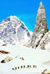
SKARDU
: Perched at a height of 7500 Ft, Skardu is located amidst an
impressive landscape, towering mountains, deep gorges, cascading
waterfalls, creeping glaciers and quiet lakes. Skardu is in the heart
of a towering frontier land. To its north lies the Sinkiang province
of China, to the south Kashmir, to the West Gilgit
and to the east the district of Ladakh in India.
Skardu is the trekker and mountain climbers paradise. Nowhere can you
find such a collection of lofty peaks and glaciers .The Baltoro
Glacier, the best known, is that spectacular conjunction of Godwin
Austen and Baltoro glaciers called Concordia, lying in the
heart of the most heavily glaciated region outside the polar areas.
Within a radius of 12 miles rise six peaks over 20,000 Ft.
This is the center of the densest concentration of lofty peaks on
earth. Some of these magnificent mountains in the Karakoram range are
Masherbrum (25,600 Ft), Mustagh tower (23,690 Ft), K-2 (28,741 Ft),
Broad Peak (26,400 Ft), Gasherbrum IV (26,810 Ft), Sia Kangri (24,350
Ft) Golden Throne (23,989 Ft), Mitre Peak (19,718 Ft), Chogolisa
(25,110 Ft) and Hidden Peak (26,470 Ft) and many others.
|
Go on Top |
|
AYUBIA : 24 kms
beyond Murree lies the enchanting hill resort of Ayubia,
named after Field Marshall Ayub Khan. A cluster of 4 different
villages and chair lift to a hill park greet the visitors.
Nathiagali, at an elevation of 2500 meters (8200 ft) is the
highest and most majestic of all the Gallis. Clouds trapped amidst
pine forest are a common site; pink maple chestnuts blossoms add an
unforgettable fragrance to the air. Majestic oaks complete this
idyllic picture - truly an exhilarating experience.
|
|
|
BAHRIAN : At 1400 meters
Bahrain is another tourist attraction of Swat located at the
picturesque junction of the roaring Swat River and the rushing Bahrain
Nulla. The one lane bazaar offers colorful embroideries, handicrafts
and local antiques. There are dozens of small hotels and
restaurants with their balconies overlooking the rivers. This is an
interesting area for explorers, who could stumble on important
archaeological findings. From here the road starts to climb
steeply towards Kalam. The bare mountains close in on the road, which
drops away precipitously to the river. Beyond Bahrain is Kohistan
where the Pushto tribe gives way to the Torwalis and Bushkaris.
|
|
|
|
Go on Top |
BALAKOT
: The gateway to the Kaghan Valley, is a little way up the
Kunhar River, 72 kms (45 miles) from Abbotabad. The small bustling
town with its colorful bazaar and the old wooden bridge over the
rushing Kunhar river are set up with a picturesque backdrop of
pine covered slopes. The huge boulders on these slopes dotted with
countless bullet holes tell the story of the battle between the
Muslims and the Sikhs fought in the mid 19th century. Its main road
connects the town with Shogran and Naran the main tourist attractions
of the Kaghan Valley.
|
|
|
BUTKARA
temple was built in the 2nd century B.C by Mauryan Emperor
Ashoka to house some of the ashes of Buddha. In subsequent
centuries it was enlarged five times by adding new shells around the
original stupa, each stupa completely enclosing the old one inside.
Later 215 Votive Stupas were built around the main stupa, all
decorated with schist columns, lions with curly manes, eagles, lilies,
cupids and lotus flowers. Some of the best stone carvings have been
removed to the museums around the world.
|
|
|
CHITRAL:
Chitral forms the North-Western roof of the Indian Sub Continent. The
rugged Hindukush range comprises Chitral's Northern and
Westerly borders while the imposing Hindu Raj mountains isolate it
from the South. This isolated valley was once in the domain of
Alexander who marched through Chitral in 327 B.C. The Adamzada,
the old ruling clan, proudly traces the linkage to the 14th century
Tartar Emperor, Tamerlane. These governors called Mehatars dominated
the state for 350 years until about 1960 when Chitral's
statehood ended. Now Chitral is directly governed by Pakistan. The
highest mountains of the Hindukush, Tirich Mir (25,264 ft) over
shadows the Chitral town. |
|
The best way to see the petite town of Chitral is on foot. The walk
tour may begin by visiting the Shahi Mosque, built by the
Mehatars, overlooking the Chitral river. The highest mountain of the
Hindukush, Tirich Mir (7788 meters) solemnly overlooks the entire
town. Chitral Fort, a grim imposing building that tells the
tales of the days of the siege of Chitral in 1895. The guns of Cols
Kelly and Roberts, Gen Low and Captain Ross are well maintained in the
fort. Chitral Bazaar is known for hunting semi precious stones
& handicrafts; such as waist coasts, belts, caps, woolen rugs, silver
jewelry, embroideries, shoes, musical instruments and baskets.
|
|
DEOSAI PLATEAU
: Known for the rolling grasslands studded with multicolored flowers,
sporadic windstorms, haunting desolation and enthralling wildlife, the
seldom visited Deosai Plateau (now a national park & protected area)
is located in the southwest-northwest of Skardu, at 4,300 meters
(14,000 feet) and is the natural habitat of the Great Himalayan Brown
Bear (equal to size of the American Grizzly) & Himalayan Marmots. The
undulating slopes of Deosai Plateau domain several summer swamps and a
unique replica of Arctic Tundra with many interesting alpine and
Arctic plant forms. Most species bloom at the same time - during the
brief summer of July and August when, addition to sedges, grasses and
dwarf willows, many plants grow in tufts and some form compact
cushions.
|
|
KHALPLU
: Guarding the trade route to Ladakh along the Shayok River,
Khaplu was the largest kingdom in Baltistan. It is located 103
Kilometers (64 Miles) in the South East of Skardu. A dramatic jeep
ride of 5 hours proceeds along the meandering Shayok River on a bumpy
trail carving its way through the spectacular Oasis of Gol, Kiris,
Bara, Ugo and Ghawari all terraced along the steep cliffs and
rigid mountain scape. The Shayok River flows into the Indus
about 35 Kms (22 miles) from Skardu and the Khaplu road continues on
the South bank round the foot of dark grey mountains, their slopes
deeply scored by rockfall and landslides. Below the road the sand
dunes, curved and fluted by the wind, are reminiscent of Tibet. Khaplu
stretches in a wide fan from the base of a semicircular wall of
mountain, dropping some 300 meters to river level. The
scattered houses set amid terraced fields are connected by paths and
irrigation channels. The friendly open villagers always welcome the
visitors. The people of Khaplu belong to the Noor-Bakhsh sect
of Shia Muslims but are more liberal and tolerant as compared to the
Shias. The women are unveiled, like the Ismailis in Hunza.
Dominating the valley from the top of the alluvial fan, the
imposing palace of the ex-ruler overlooks the village. Its
whitewashed facade, punctuated by irregularly placed little windows,
support an extravagant four-tier carved wooden balcony up its center.
Built 200 years ago, it has a faintly Tibetan air. At
2600 meters (8400 feet) Khaplu is cooler than Skardu, which
when combined with the friendly character of the people and the superb
walks along the irrigation channels makes Khaplu the nicest place to
stay in Baltistan.
|
|
|
DIR (DEER)
: The independent Kingdom of Dir was absorbed into Pakistan only in
1962. Since one of the main trade routes from Eastern Afghanistan
passed through lower Dir, there are several places of historical
interest to be seen along the road among which Talash Valley, Kat
Kala Fort and Timargarha are quite rich in their archaeological
heritage left by the Aryans , Buddhists, Hindus and Muslims. None of
these remains has been excavated, but they date from the second to the
ninth century. Dir has a well wooded countryside with fine views. This
beautiful town is inhabited by the upright, fierce yet very hospitable
Pathans whose prestige is earned, maintained and avenged by a
bullet. |
|
|
|
Go on Top |
GARAM CHASHMA
: "Garam" means "Hot" and "Chashma" means "Spring". 45 kms
north-west of Chitral, these Hot Sulphur Springs are known around the
world for curing skin diseases, gout, rheumatism and headaches. The
paved road follows the south bank of Lutkho river through a
steep-sided gorge and emerges into the green and wooded valley guarded
by a mud walled fort. This is the picturesque Lutkho valley which arcs
north-west from Chitral to the Afghan frontier. It is a scenic, stark
chasm of barren red rock walls and precipitous scree slopes,
punctuated by incredibly green oases in occasional spots of bottom
land. Rice and corn crops are watered by intricate irrigation
systems, on terraces walled off by generations. A hard land fitting
to the large Afghan refugee population which now shares living space
with their native brothers.
|
|
|
KAGHAN VALLEY
: Terraced from river to hilltop and covered in forests of huge
Himalayan pine, the Kaghan Valley is one of the most beautiful
in Pakistan and is reminiscent of the alpine scenery of Europe. Kaghan
is just on the edge of the monsoon belt, so there is no need for
irrigation here. The slopes are steep, and villages cling precariously
to the sides of the hills, the tops of which are often hidden by
clouds. Kaghan is not on the normal tourist route: it is for the lover
of nature, hiking, fishing and other outdoor pleasures. |
|
|
Most confusingly, there is no Kaghan River, rather, the Kunhar
River flows through the Kaghan Valley, down from high in the Indus
Kohistan to join the Jehlum at Muzaffarabad. The valley is over 160
kilometers (100 miles) long and climbs from about 900 meters (3,000
feet) at Balakot to 4,173 meters (13,690 feet) at the Babusar Pass.
The road through the valley and up over the Babusar Pass to Chilas on
the Indus opened in 1898; it was the main route to the Northern Areas
and Gilgit before the Karakoram Highway was opened in 1978. Closed for
most of the year by heavy snow, the Babusar Pass is only jeepable for
the short summer months. |
|
|
|
Go on Top |
|
KALAM
: Kalam is at 2100 meters, it slopes down gradually,
terminating in a sharp drop to the main roadway and river. Upper Swat
or Kohistan belongs culturally to the northern region as the
architecture of the old mosque and the carvings of wooden pillars,
window frames and door jambs indicate. Although there is no road from
here to Chitral or Gilgit, the upper northern cultural influence must
have filtered in along the food trails. This region is the boundary
marking cultural changes from south to north. Kalam has a tranquil
air and a pleasant climate during the day, though nights tend to be
cold. On a clear day you can see the 5918 meter high Mt Falaksair
from the upper section of the town. In the north-east of the valley
its snow-clad upper slopes and peak rise above dense, lush forests.
The river rushes through the town, right across from the old mosque.
The wooden mosque of Kalam is the highlight of the whole valley &
worth paying a visit.
|
|
|
|
|
|
|
|
|
|
Go on Top |
|
|
|
|
|
|
|
|
Go on Top |
|