|
Pakistan
Guides |
|
EXPEDITION PACKAGES FOR
8000 METER PEAKS
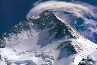
K2 / CHOGHORI (8616 M)
GASHERBRUM I (8068 M)
BROAD PEAK (8047 M)
GASHERBRUM II (8035 M)
NANGA PARBAT (8125 M)
|
|
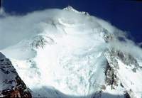
BROAD
PEAK
(8,047 M) - EXPEDITION PACKAGE
(Map of Broad Peak)
|
Altitude
(Height)
|
8,047
Meters (26,394 Feet)
|
|
Location
(Bearings)
|
N-35°.48′
– E 76°.34′
|
|
Range
/ Group
|
Karakoram
/ Baltoro Muztagh
|
|
Region
/ Glacier
|
Baltistan
/ Godwin Austin
|
|
Permit
Zone
|
Regulated
(Needs Army L.O)
|
|
Best
Climbing Time
|
Mid
May – Mid Aug
|
|
Normal
Permit Fee
|
US$
9,000 (for 07 persons)
|
|
Discounted
Fee
|
US$
4,500 (for 7 persons)
|
|
Duration
/ Climbing
|
50
Days / 30 Days
|
|
 |
|
|
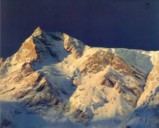
The local name of
Broad
Peak is Falchen Kangri, however, due to the immense
and broad bulk of this peak, it’s called the
Broad
Peak
. At 8047, this is the world’s 12th highest peak and
considered as one of comparatively easier 8000 meter peaks.
Following the conventional climbing style, this peaks needs to
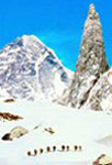
establish at least three camps at 6000M, 6500M, and 7200M.
The approach to
Broad
Peak
goes through the Baltoro Glacier which has been rightly reckoned as the greatest museum of shape & form
on earth by the famous Italian explorer Fosco Maraini.
There are several high peaks which rise from the world’s
largest temperate zone glacier. An incredible nineteen of these
peaks tower over 7600m while four of them are above 8000.
Only the superlatives can define the beauty and grandeur witnessed
on this "sublime sanctuary of nature".
Known as the most spectacular trek in the world, the traditional
expedition route to
Pakistan ’s
Four
Eight
Thousand
Meter
Peaks
cuts through the greatest concentration of some of the highest peaks
in the world. Not only are the mountains high, but they are the most
jagged and sheer than the monoliths of
Nepal
. 08 of the world's 30 highest peaks of the world stand
around this unusual trek. The apex of this incredible trek is Concordia one of the
biggest peadmont glaciers of the world. It is a
spectacular junction of Godwin Austin Glacier, Abruzzi
Glacier and Baltoro Glacier. It banks, 06 peaks over 25,912 ft
(7900 M) within a short radius of 07 miles (11 Km).
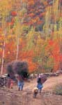
The walk to Concordia, however, is a challenging trek up and down
the gorges, across rushing icy torrents, through broken rocks, over
wire-rope bridges and through crevassed glaciers. The incentive for
this strenuous walk is undoubtedly equally rewarding. Chongo
Brakk, Mango Gusar, Sobla, Chiring, Bakhordas, Bardumal, Liligo,
Paiju, Trango Towers Group, Uli Biaho Towers, Mitre Peak, Muztagh
Tower, Gasherbrum 3, 4, 5 & 6, Broad Peak, Chogolisa, Golden Throne,
Sia Kangri, Angles, Marble Peak & the Mighty K-2 are just a
few of the innumerable mountain vistas to be witnessed on this trek
in addition to tranquil lakes, blossoming fruit orchards, meandering
rivers, tumbling water falls and undulating sand dunes with a unique
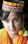
blend of the modest Balti culture marked with distinct
language, architecture and dresses. Although on the entire trek we
are in absolute wilderness, we will take a colorful part of the
Karakoram Culture with us. Our scores of lively Baltis and
Hunzakuts who are tough enough to sing and dance after the hard
day's work.
TRIP
SUMMARY:
Duration: 50 Days, Camping Nights: 41, Climbing: 30 Days, Hotels: 09
Nights, Start: Skardu/Askole, End: Hushe/Skardu, Approach March : 07
Days, Domestic Flights : 02, Jeep Drive: 02 Days
SKETCH ITINERARY :
Day 01:
Arrive
Islamabad
. Transfer to Hotel. Inspection of food & equipment. Night in Hotel.
Day 02:
Documentation & briefing
at Ministry of Tourism. Local chores & packing. Overnight in Hotel.
Day
03:
Fly to Skardu by weather permitting flight or drive to Chilas, if
unable to fly (490 km). In Hotel.
Day
04:
Local chores in Skardu or complete road journey (275 km), if
unable to fly yesterday. In Hotel.
Day 05:
Drive to Askole by jeep (7hrs, 3000m). Hire porters, distribute
loads. Overnight in camp.
Day 06-12: Trek to
Broad
Peak
Base via Korophone, Bardumal, Paiju, Liligo, Urdukas, Goro &
Concordia.
Day 13-42:
30 days for climbing. Services available only upto base camp.
All nights in camps.
Day 43-46:
Walk
back to
Hushe
Valley via
Gondogoro
Pass
and drive back to Skardu by jeep. In Hotel.
Day 47 & 48:
Fly or drive to
Islamabad
via Chilas. Local chores in
Islamabad
. Overnight in Hotel.
Day 49:
Islamabad
: De-briefing at
Ministry of Tourism. Packing for homebound flight.
Day 50:
Transfer to
Islamabad
airport & embark your home bound flight.
Click Here, For Expedition Services
|
Go on Top
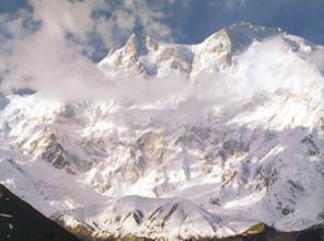
GASHERBRUM
I (8,068
M) - EXPEDITION PACKAGE
(Map of Gasherbrum 1)
|
|
Altitude
(Height)
|
8,068
Meters (26,463 Feet)
|
|
Location
(Bearings)
|
N-35°.43′
– E 76°.42′
|
|
Range
/ Group
|
Karakoram
/
Gasherbrum
|
|
Region
/ Glaciers
|
Baltistan
/ Baltoro
& Abruzzi
|
|
Best
Climbing Time
|
Mid
May – Mid Aug
|
|
Permit
Zone
|
Regulated
(Needs Army L.O)
|
|
Normal
Permit Fee
|
US$
9,000 (for 07 persons)
|
|
Discounted
Fee
|
US$
4,500 (for 07 persons)
|
|
Duration
/ Climbing
|
60
Days / 40 Days
|
|
 |
The
conventional climbing route to the summit of this spectacular peak
is from the plateau on the Gasherbrum Glacier, however, another more
popular route in the recent years has been the
Gasherbrum
Pass
upto the Japanese Culvert along the north ridge. Yet another route
is from the west ridge which is technically less difficult but takes
longer time due to longer distance between camp 1 and its summit.
While the lower part imparts some technical difficulties, the upper
snow face also threatens danger of avalanches,
 especially
after fresh snow falls. especially
after fresh snow falls.
TRIP
SUMMARY:
Duration: 60 Days, Camping Nights: 51, Climbing: 40 Days, Hotels: 07
Nights, Start: Skardu/Askole, End: Hushe/Skardu, Approach March: 07
Days, Domestic Flights: 02, Jeep Drive: 02 Days
SKETCH
ITINERARY :
Day
01:
Arrive
Islamabad
. Transfer to Hotel. Inspection of food & equipment. Overnight
in Hotel.
Day
02:
Documentation & briefing
at Ministry of Tourism. Local chores & packing. Overnight in
Hotel.
Day
03:
Fly to Skardu by weather permitting flight or drive to Chilas, if
unable to fly (490 km). In Hotel.
Day
04:
Local chores in Skardu or complete road journey (275 km), if
unable to fly yesterday. In Hotel.
Day
05:
Drive to Askole by jeep (7hrs, 3000m). Hire porters, distribute
loads. Overnight in camp.
Day
06-12: Trek to G-1 Base Camp. Via Korophone, Bardumal, Paiju, Liligo, Urdukas,
Goro & Concordia.
Day 13-52:
40 days for climbing. Our services will be available only
upto base camp. All nights in camps.
Day
53-56:
Walk back
to
Hushe
Valley
via
Gondogoro
Pass
and drive back to Skardu by jeep.
Day
57 & 58:
Fly or drive to
Islamabad
via Chilas. Local chores in
Islamabad
. Overnight in Hotel.
Day 59: In
Islamabad
: De-briefing at
Ministry of Tourism. Packing for homebound flight. Night in Hotel.
Day
60:
Transfer to
Islamabad
airport. Fly home. End of our services.
Click Here, For Expedition Services
|
Go on Top
GASHERBRUM
II (8,035
M) - EXPEDITION PACKAGE
(Map of Gasherbrum II)
|
|
Altitude
(Height)
|
8,035
Meters (26,355 Feet)
|
|
Bearings
/ Location
|
N-35°.45′
– E 76°.39′
|
|
Range
/ Group
|
Karakoram
/
Gasherbrum
|
|
Region
/ Glaciers
|
Baltistan
/ Baltoro & Abruzzi
|
|
Permit
Zone
|
Regulated
(Needs Army LO)
|
|
Best
Climbing Time
|
Mid
May – Mid Aug
|
|
Normal
Permit Fee
|
US$
9,000 (for 07 persons)
|
|
Discounted
Fee
|
US$
4500 (for 07 persons)
|
|
Duration
/ Climbing
|
60
Days / 40 Days
|
|
 |
Mountaineers
have reckoned the approach march to the base camp of this beautiful
peak as the most spectacular trek in the world. Though, smallest in
the family of 8000ders in
Pakistan
, its climb happens to be inspiring and rewarding. Gasherbrum II
stands in the vicinity of K-2 with a panorama of many other
spectacular peaks around Concordia, such as
Broad
Peak
, Gahserbrum1, Sia Kangri, Baltoro Kangri etc.
After
tramping the heavily crevassed glacier, the snow faced South-West
Ridge which is studded with mixed faces is quite challenging with
substantial difficulties, whereas, some of its sections are very
steep. One may continue climbing a series of ridges from above the
elongated ridge and reach a platform where is ideal for setting up
camp 2. From this point
onward, two ice pitches and up you go steeper before one reaches the
shoulder. Camp 3 is made at 7490M and after three pitches from here,
one climbs diagonally across the face. A traverse leads to the base
of its summit on he Eastern Ridge. The wide open expanse offers a
straight climb with a few steep sections before one reaches the
narrow summit ridge.
TRIP
SUMMARY:
Duration: 60 Days, Camping Nights: 51, Climbing: 40 Days, Hotels: 07
Nights, Start: Skardu/Askole, End: Hushe/Skardu, Approach March: 07
Days, Domestic Flights: 02, Jeep Drive: 02 Days
SKETCH
ITINERARY :
Day
01:
Arrive
Islamabad
. Transfer to Hotel. Local chores. Inspection of food &
equipment.
Day
02:
Documentation & briefing
at Ministry of Tourism. Local chores & packing. Overnight in
Hotel.
Day
03:
Fly to Skardu by weather permitting flight or drive to Chilas, if
unable to fly (490 km). In Hotel.
Day
04:
Local chores in Skardu or complete road journey (275 km), if
unable to fly yesterday. In Hotel.
Day
05:
Drive to Askole by jeep (7hrs, 3000m). Hire porters, distribute
loads. Overnight in camp.
Day
06-12: Trek to G-II Base Camp. Via Korophone, Bardumal, Paiju, Liligo, Urdukas,
Goro & Concordia.
Day 13-52:
40 days for climbing. Our services will be available only
upto base camp. All nights in camps.
Day
53-56:
Walk back
to
Hushe
Valley
via
Gondogoro
Pass
and drive back to Skardu by jeep.
Day
57 & 58:
Fly or drive to
Islamabad
via Chilas. Local chores in
Islamabad
. Overnight in Hotel.
Day 59: De-briefing
at Ministry of Tourism in
Islamabad
. Packing for homebound flight. Night in Hotel.
Day
60:
Transfer to
Islamabad
airport. Fly home. End of our services.
Click Here, For Expedition Services
|
Go on Top
|
|
K2
/ CHOGHORI (8,616 M) - EXPEDITION PACKAGE
(Map of K-2)
|
Altitude (Height)
|
8,616 Meters (28,260 Feet)
|
|
Location (Bearings)
|
N 35°.53′ – E 76°.31′
|
|
Range / Group
|
Karakoram / Baltoro Muztagh
|
|
Region / Glacier
|
Baltistan / Godwin Austin
|
|
Permit Zone
|
Regulated (Needs Army L.O)
|
|
Best Climbing Time
|
Mid May – Mid Aug
|
|
Normal Permit Fee
|
US$ 12,000 (for 07 persons)
|
|
Discounted
Fee
|
US$ 6,000 (for 07 persons)
|
|
Duration / Climbing
|
80 Days / 60 Days
|
|
 |
K2 is the second highest
mountain of the world and the highest in the
Karakoram range . Its original name is
Chogori in Balti language, which means the great mountain.
Karakoram means Back Rock in Turkish. K-2 was first discovered by a
British Army Officer - Capt. Montgomery while surveying a number of peaks in the region in
1856. He found a thick cluster of high peaks and named them K1, K2,
K3 upto K 37 using the prefix K as
Karakorum
. In 1861, this area was once again surveyed by Col. Godwin Austin who reckoned K2 as the highest peak of the
Karakoram range at 8619 meters, only three meters higher
than its correct height 8616 which was measured with most modern
scientific equipment in 1986. This great mountain is located on the
Godwin Austin and Concordia Glaciers. It
was first climbed by Italians in 1954.
The approach to
K2 goes through the Baltoro Glacier which has been
rightly reckoned as the greatest museum of shape & form
on earth by the famous Italian explorer Fosco Maraini.
There are several high peaks which rise from the world’s
largest temperate zone glacier. An incredible nineteen of these
peaks tower over 7600m while four of them are above 8000.
Only the superlatives can define the beauty and grandeur witnessed
on this "sublime sanctuary of nature".
Known as the most spectacular trek in the world, the traditional
expedition route to K-2 (Chogori) 8616 M - the second highest
mountain on Earth, cuts through the greatest concentration of
some of the highest peaks in the world. Not only are the mountains
high, but they are the most jagged and sheer than the monoliths of
Nepal
. 08 of the world's 30 highest peaks of the world stand
around this unusual trek. The apex of this incredible trek is
Concordia one of the
biggest peadmont glaciers of the world. It is a
spectacular junction of Godwin Austin Glacier, Abruzzi
Glacier and Baltoro Glacier. It banks, 06 peaks over 25,912 ft
(7900 M) within a short radius of 07 miles (11 Km).

The walk to Concordia, however, is a challenging trek up and down
the gorges, across rushing icy torrents, through broken rocks, over
wire-rope bridges and through crevassed glaciers. The incentive for
this strenuous walk is undoubtedly equally rewarding. Chongo
Brakk, Mango Gusar, Sobla, Chiring, Bakhordas, Bardumal, Liligo,
Paiju, Trango Towers Group, Uli Biaho Towers, Mitre Peak, Muztagh
Tower, Gasherbrum 3, 4, 5 & 6, Broad Peak, Chogolisa, Golden Throne,
Sia Kangri, Angles, Marble Peak & the Mighty K-2 are just a
few of the innumerable mountain vistas to be witnessed on this trek
in addition to tranquil lakes, blossoming fruit orchards, meandering
rivers, tumbling water falls and undulating sand dunes with a unique
blend of the modest Balti culture marked with distinct
language, architecture and dresses. Although on the entire trek we
are in absolute wilderness, we will take a colorful part of the
Karakoram Culture with us. Our scores of lively Baltis and
Hunzakuts who are tough enough to sing and dance after the hard
day's work. We will be invited to join in. There will be many
memorable evenings listening to their songs and watching their
dances.
TRIP
SUMMARY:
Duration: 80 Days, Camping Nights: 70, Climbing: 60 Days, Hotels: 07
Nights, Start: Skardu/Askole, End: Hushe/Skardu, Approach March : 07
Days, Domestic Flights : 02, Jeep Drive: 02 Days
SKETCH ITINERARY :
Day 01:
Arrive
Islamabad
. Transfer to Hotel. Local chores. Inspection of food & equipment.
Day 02:
Documentation & briefing
at Ministry of Tourism. Local chores & packing. Night in Hotel.
Day
03:
Fly to Skardu by weather permitting flight or drive to
Chilas, if unable to fly (490 km).
Day
04:
Local chores in Skardu or complete road journey (275 km), if
unable to fly yesterday. Hotel.
Day 05:
Drive to Askole by jeep (7hrs, 3000m). Hire porters, distribute
loads. Overnight in camp.
Day 06-12: Trek to
K2 Base Camp. Via Korophone, Bardumal, Paiju, Liligo,
Urdukas, Goro & Concordia.
Day 13-72:
60 days for climbing. Our services will be available only
upto base camp. All nights in camps.
Day 73-76:
Walk
back to
Hushe
Valley via
Gondogoro
Pass
and drive back to Skardu by jeep.
Day 78 & 79:
Fly or drive to
Islamabad
via Chilas. Local chores in
Islamabad
. Overnight in Hotel.
Day 80: In
Islamabad
: De-briefing at
Ministry of Tourism. In evening fly home.
Click Here, For Expedition Services
|
Go on Top
|
|
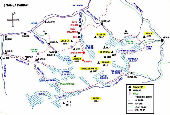
NANGA
PARBAT
(8125 M) - EXPEDITION PACKAGE
(Map of Nanga Parbat)
|
Altitude
(Height)
|
8,125
Meters (26,650 Feet)
|
|
Location
(Bearings)
|
N
35°.14′ – E 74°.35′
|
|
Range
/ Group
|
Himalayas
/
Nanga Parbat
|
|
Region
/ Glacier
|
Diamer
(Chilas) / Diamori
|
|
Permit
Zone
|
Open
Zone (No Army L.O)
|
|
Best
Climbing Time
|
Mid
May – Mid Aug
|
|
Normal
Permit Fee
|
US$
9,000 (for 07 persons)
|
|
Discounted
Fee
|
US$
4,500 (for 07 persons)
|
|
Duration
/ Climbing
|
50
Days / 40 Days
|
|
 |
 The
Naked
Mountain
, as interpreted in
the local language, is the Ninth
in height but the First
in Actual Climb
challenge & dignity in the world. Standing at the extreme
western end of 24,000 Km Himalayan Range - just beyond the deep
Indus
Valley
, culminates in an ice crest, 8125
M high. No other peak within 100
Km comes anywhere near it's size. It
is separated from the Karakoram by the mighty
Indus
River
.
Nanga Parbat
is not a single peak but consists of 20km long series of peaks and
ridges. It is the second highest
mountain in
Pakistan
. The
Naked
Mountain
, as interpreted in
the local language, is the Ninth
in height but the First
in Actual Climb
challenge & dignity in the world. Standing at the extreme
western end of 24,000 Km Himalayan Range - just beyond the deep
Indus
Valley
, culminates in an ice crest, 8125
M high. No other peak within 100
Km comes anywhere near it's size. It
is separated from the Karakoram by the mighty
Indus
River
.
Nanga Parbat
is not a single peak but consists of 20km long series of peaks and
ridges. It is the second highest
mountain in
Pakistan
.
It's
incomparable Rupal Face (southern side) is one of the greatest
precipices in the world - a sheer drop of 5000 M,
while the
North or Raikot Face plunging over (7000m) from the summit to the
Indus River forms one of the world’s deepest gorge.
Also
notorious as the
Killer
Mountain
, it has so far taken the biggest toll of human lives in the anal of
mountaineering. Influenced by the centuries old legends, the locals
believe beyond their doubts that
Nanga Parbat
is an eternal abode of Fairies & Demons who frequently curse
their fury over the undesirable intruders
in shape of roaring avalanches. The locals thus alarmingly warn
mountaineers to keep their feet off this dangerous mountain. It
is believed that the Queen of fairies lives in a Crystal Castle
guarded by gigantic snow serpents and frogs. The earlier disasters
in climbing this mountain are attributed to the displeasure of
fairies.
The
first visual record of this mountain was a canvas painted by Rudolf
Schlagintweit - a German traveler, who beheld this mighty
peak in 1852.
Nanga Parbat
was first climbed in 1953
by a joint Austrian – German Expedition. Hermann Buhl made the
final ascent in 41 hour solo climb without oxygen. Italian
mountaineer Reinhold Messner climbed the south face (Rupal Face)
with his brother Gunter in 1970, descending by Diamer face, where
Gunter lost his life.
HISTORY
OF
NANGA PARBAT
Nanga
Parbat
is one of the most challenging Peaks of the world. It is also called
the
Killer
Mountain
as it has taken the biggest toll of human lives in the annals of
mountaineering. German expeditions were the worst victims but the
mountain also eventually surrendered itself to the Germans for the
first time in 1953 and again in 1962 who mounted as many as ten
attacks on it between 1932 & 1970. The main peak has been
climbed 11 times so far.
Nanga
Parbat
first tasted blood in 1895 when the famous British mountaineer A.F.
Mummery, attempted to scale it with a small team which included Gen.
C.G. Bruce. The leader and two Gurkha porters were killed.
It
was after 37 years that Willy Markl took a German expedition to the
mountain in 1932 and again in 1934 when four climbers, including the
leader and seven porters, died.
The
worst tragedy befell the German expeditions under Karl Wein in 1937
when the entire team of sixteen, including porters was buried deep
under a massive avalanche while sleeping their tents. The Germans
came again in 1938 and 1939 and failed.
Sherpa
Tenzing Norgay, who climbed Everest in 1953 came to
Nanga Parbat
in 1950 with three British officers of Gurkha Regiments but their
attempts also failed. The
persistent and costly efforts of German were ultimately rewarded in
1953 when Dr. Karl Herrligkoffer, brought an expedition under the
leadership of Peter Aschenbrenner and conquered it on July 3rd.
Hermann Buhl was the man who finally did it. He made a solo attempt
beyond Camp-VI and reached the summit where he had to spend the
night in a thin pullover and survived.
Dr.
Herrligkoffer led another successful expedition to
Nanga Parbat
in 1962. A Czech expedition under Ivan Galfy in 1971 conquered the
mountain, whereas a similar one in 1969 had failed.
Reinhold
Messner and his brother Gunter Messner conquered the peak on 27
June, 1970 but on their return from the summit Gunter fell into a
crevasse and got lost.
An
Austrian expedition with Hans Schell as leader in 1976 was
successful. Attempts by the American and Polish expeditions next
year met with failure.
The
Killer
Mountain
yielded again to two expeditions in 1978, the upper Austrian
Himalayan expedition of Rudolf Warzer and the Italian expedition
under Reinhold Messner who climbed the peak for the second time. Wanda
Rutkievicz was the leader and one of the summiteers of a successful
women expedition on 15th July, 1985.
The
latest expedition to mount their summiteers on
Nanga Parbat
were Spanish, Belgium/Dutch and Italian expeditions all succeeded in
summer 1986.
SOME
OF THE SUCCESSFUL EXPEDITIONS ON
NANGA
PARBAT
1953
Jul 03 Herman Buhl
1962
Jul 22 Toni
Kinshofer, Anderal Mannhardt, Sigi Low
1970
Jun 27 Gunther
Messner, Reinhold Messner
1970
Jun 28 Felix
Kuen, Peter Sholz
1971
Jul 11
I.
Felix Kuen, Peter Scholz
1976
Aug11 H. Schell, S. Gimpel, R. Schauer, H. Sturm
1978
Aug 09 Reinhold Messner
1981
Aug 5
Ronald Naar
1981
Aug 19 L. Rota, B. Scanabessi, S. Fassi
1982
Jul 14 Hans
Engl
1982
Aug ??
Vehli Buhler (
South Summit
)
1983
Jun 10 Norbert
Joos, Erhard Loretan
1983
Jul 18 Edi
Koblmuller
1983
Jul 31 Japanese
Expedition
1984
Jun 27 Liliane
Barrard, Maurice Barrard
1985
Jul 8
Bernard Muller, Laurence De La Ferriere
1985
Jul 11 Michael
Dacher, Peter Habler
1985
Jul 13 Zygmunt
Hienrich, Jerzy Kukuczka, Slanorir Lobodzinski, Carlos Carsolio
1985
Jul 15 Ana
Czer Winska, Krystyna Palmowska, Wanda Rutkiewicz
1986
Jul ??
Miguel Gomez Snachez, C/Pintor Vilar.
1986
Jul ??
Vanhees Jan Puttekomheide
1986
Jul ??
Gunnella Marco
TRIP
SUMMARY:
Duration: 50 Days, Camping Nights: 43, Climbing: 40 Days, Hotels: 06
Nights, Start: Islamabad/Chilas End: Chilas/Islamabad, Approach
March : 02 Days, Domestic Flights : Nil,
Jeep Drive
: 02 Days.
SKETCH
ITINERARY :
Day
01:
Arrive
Islamabad
. Transfer to Hotel. Inspection of food & equipment. Overnight
in Hotel.
Day
02:
Documentation & briefing
at Ministry of Tourism. Local chores & packing. Night in Hotel.
Day
03:
Drive to Chilas by bus on the
Karakoram Highway
. (490 km). Overnight in Hotel.
Day
04 & Day 05 : Drive to Halala by jeep and trek to Diamer Base
Camp. Night in camp.
Day
06 to Day 45 :
40 days for climbing. Our services only upto base camp. All nights
in camps.
Day
46 & Day 47 :
Trek back to Halala & drive by Jeep to Chilas. Overnight in Hotel
Day 48 :
Drive down on the
Karakorum Highway
to
Islamabad
. Overnight in Hotel.
Day
49 :
Debriefing at Ministry of Tourism. Packing for homebound flight.
Overnight in Hotel.
Day
50 :
Transfer to
Islamabad
airport. Fly home.
Click Here, For Expedition Services
|
|

